
Exercise 1
Embibe Experts Social Science Solutions for Exercise 1
Simple step-by-step solutions to Exercise 1 questions of India-Size and Location from Social Science Textbook of Competency Based Questions for Class IX. Also get 3D topic explainers, cheat sheets, and unlimited doubts solving on EMBIBE.
Questions from Exercise 1 with Hints & Solutions
Imagine a scenario where a group of geologists is conducting a comprehensive study on the geological history of India. During their research, they come across a region with prominent fold mountain ranges. These mountains have been formed as a result of recent tectonic activity. The team identifies that these mountains run across the northern, northwestern, and northeastern boundaries of India. As they examine the geological data, they stumble upon the presence of young fold mountain ranges in India.
Now, based on their findings, they need to determine which of the following mountain ranges are indeed these young, actively folded mountains:
A team of cartographers is working diligently to create an accurate and comprehensive geographical map of India. In their endeavor, they need to arrange Indian states in groups based on their geographical locations. However, the task is not as straightforward as it seems. The cartographers divide into groups, and each group is assigned a set of Indian states to organize. Their goal is to correctly group these states based on their geographical locations within India. They discuss and analyze the states in their respective groups and consider their positions in relation to one another on the map.
Now, the cartographers face the challenge of determining which group among the following contains the states that are correctly organized in terms of their geographical locations:
The Arabian Sea is a vast body of water situated in the northwestern part of the Indian Ocean. It is surrounded by several countries, including India, Pakistan, Oman, Yemen, Somalia, and various other nations on the Arabian Peninsula. The Arabian Sea is an integral part of the maritime geography of South Asia and the Middle East, and it plays a crucial role in trade, transportation, and natural resource exploration in the region.
Which groups of Indian states have coastal access to the Arabian Sea?
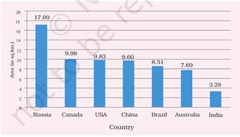
Analysing the provided graphical representation, which includes data on the geographical areas of the seven largest countries, which of the following statements accurately describes the relative sizes of these countries in terms of land area, taking into account factors like territorial extent, regional distribution, and their positioning amongst the largest nations in the world?
In the heart of New Delhi, young Priya was fascinated by the concept of time. Her grandfather, an old scholar, told her the story of how Indian Standard Time (IST) became related to Greenwich Mean Time (GMT). Long ago, before railways and telegraphs, each town in India had its own local time based on the position of the sun. This made communication and transportation confusing. The British colonial rulers recognized the need for a standard time, so they decided to use GMT as the reference point.
Explore the historical background of Indian Standard Time (IST) and its connection to Greenwich Mean Time (GMT), and elucidate the far-reaching significance of this synchronization for India, considering how it impacted the country's administration, trade, and communication, and its role in unifying a geographically diverse nation.
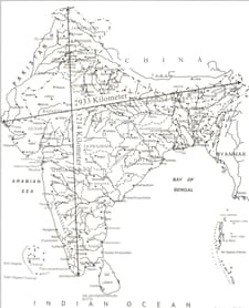
Analyse the given image and provide a detailed geographic description of India's boundaries at the four cardinal directions, elucidating the specific geographical features, neighboring countries, and their significance, considering factors such as international relations, climate, and topography, in shaping India's regional diversity
On a detailed map of India, accurately identify and mark the Indian states through an important latitude at N passes.


