
Examine the map of Jammu and Kashmir given below
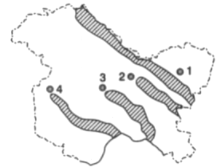
The mountain ranges marked 1, 2, 3 and 4 are respectively
Important Questions on Indian Geography
In the map given below, three out of the four places marked indicated the places where thermal power stations are located:
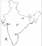
The place where there is a Hydel power project is marked:
Which one of the following rivers thrice forks into two streams and reunites a few miles farther on, thus forming the islands of Srirangapattanam, Sivasamudram and Srirangam?
As per the 1991 Census, which one of the following states has a lower population density than the other three?
In the Indian context, the term 'De-notified tribes' refers to:
High temperature and low pressure over the Indian sub-continent during summer season draws air from the Indian Ocean leading to the in-blowing of the:
'Saddle Peak' the highest peak of Andaman and Nicobar Islands is located in:
Assertion (A): Mangroves are very specialised forest eco-system of tropical and Sub-tropical regions bordering certain sea coasts.
Reason (R): They stabilize the shoreline and act as a bulwark against encroachments by sea.
In the context of the above two statements, which one of the following is correct?
Match List I (Ores) with List II (States where they are mined) as select the correct answer using the codes given below the lists:
| List I | List II |
| A. Manganese | 1.Madhya Pradesh |
| B. Nickel | 2. Odisha |
| C. Lead-Zinc | 3. Rajasthan |
| D. Asbestos | 4. Andhara Pradesh |
Codes
A B C D


