
Marginal information includes the topographical sheet number.
Important Questions on Topographical Maps
Study the extract for topographical sheet 63 K/12 shown in the flgure on page 68 and answer the following questions.

Give the height of the highest point on the map.
Study the extract from the topographical sheet No. , as shown in the figure below and answer the following questions

At which one of the banks of river Ganga, Bhatauli is located?
Study the extract for topographical sheet 63 K/12 shown in the flgure on page 68 and answer the following questions.

What type of settlement does the area have?
Study the extract from the topographical sheet No. , as shown in the figure below and answer the following questions

What means of transportation is used to cross the river by the people of Bhatauli village?
Study the extract from the topographical sheet No. , as shown in the figure below and answer the following questions

Name the villages/settlements where Post Office is located?
Study the extract for topographical sheet 63 K/12 shown in the flgure on page 68 and answer the following questions.

River Jamtihwa Nadi is flowing through which quarter of the map?
Study the extract from the topographical sheet No. , as shown in the figure below and answer the following questions

What is the direction of flow of the river Ganga?
Study the extract from the topographical sheet No. , as shown in the figure below and answer the following questions

Convert into a statement of scale.
Study the extract from the topographical sheet No. , as shown in the figure below and answer the following questions

What does the yellow colour in the area refer to?
Study the extract for topographical sheet 63 K/12 shown in the flgure on page 68 and answer the following questions.
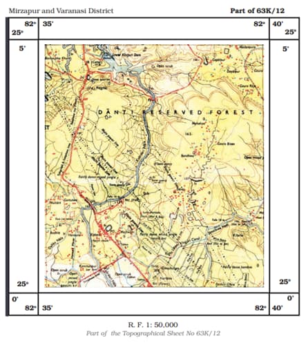
Name the geographical feature represented by white patches in the middle of Sipu Nadi.
Study the extract from the topographical sheet No. , as shown in the figure below and answer the following questions
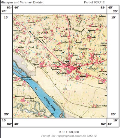
What is the pattern of rural settlements along the right bank of river Ganga?
'Marginal Information' in Topographical sheets
Study the extract from the topographical sheet No. , as shown in the figure below and answer the following questions

Name the major settlements of the area.


