
Match the locations of ports labelled as A, B, C and D in the given map with the names of those ports and select the correct answer using the codes given below the names of the ports:
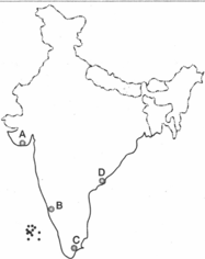
Names of Ports:
1. Kakinada
2. Karwar
3. Mangalore
4. Tuticorin
5. Veraval
Codes
A B C D
1. Kakinada
2. Karwar
3. Mangalore
4. Tuticorin
5. Veraval
Important Questions on Indian Geography
Which one of the following ports of India handles the highest tonnage of import cargo?
Which one of the following pairs of primitive tribes and places of their inhabitation is not correctly matched?
Which one of the following statements is true according to 1991 Census data?
Reason (R): There has been a reduction in the depth of river valleys due to deposition of silt.
Codes:
Assertion (A): Ganga Plain is the most densely populated part of India.
Reason (R): Ganga is the most harnessed river of India.
Codes:
Consider the following statements:
1. Tides are of great help in navigation and fishing.
2. High tide enables big ships to enter or to leave the harbor safely.
3. Tide prevents siltation in the harbors.
4. Kandla and Diamond Harbour are tidal Ports
Which of the statements given above are correct?
Match List I with List II and select the correct answer using the codes given below the lists.
| List I (Institutes) |
List II (Locations) |
||
| A | Central Institute of Higher Tibetan Studies | 1 | Hyderabad |
| B | Indira Gandhi Institute of Development Research | 2 | Mumbai |
| C | National Institute of Mental Health and Neuro-sciences | 3 | Bengaluru |
| D | Central Institute of English and Foreign Languages | 4 | Dharamshala |
| 5 | Varanasi |
Codes
A B C D


