
Refer to map and answer the following question:
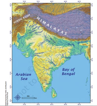
Each centimetre on the map, as printed here, represents a certain distance on the ground — let us suppose it is metres; we say that the scale is cm = m. Now, turn to the map of India given above. The scale is represented in the bottom left corner by a ruler with ’ written above its length and ‘km’ on the side. It simply means that this ruler, which measures cm in the printed map, corresponds to kilometres on the ground.
Taking the scale to be cm = km, calculate the real distance from the estuary of the Narmada River to the estuary of the Ganga river. (Hint: round off your measurement on the map to an easy number.)
Taking the scale to be cm = km, calculate the real distance from the estuary of the Narmada River to the estuary of the Ganga river. (Hint: round off your measurement on the map to an easy number.)
Important Questions on Locating Places on the Earth
Mark the following statement as true or false; explain your answers with a sentence or two:
All parallels of latitude have the same length.
Mark the following statements as true or false; explain your answers with a sentence or two:
The length of a meridian of longitude is half of that of the Equator.
Mark the following statements as true or false; explain your answers with a sentence or two.
The South Pole has a latitude of 90°S


