
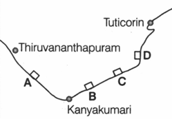
Which one of the following ports shown on the rough outline map of India is a riverine port?
Important Questions on Indian Geography
Match the following research institutes A, B, C, and D with their respective location labeled as 1 to 6 in the given rough outline map :
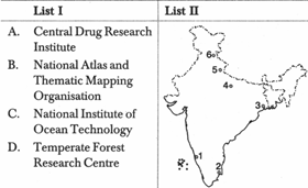
Select the correct answer using the codes given below
A B C D
Some people in Manipur live in houses built on floating islands of weeds and decaying vegetation held together by suspended silt. These islands are called
The Rawa offshore block, with great potential for oil, is located in
Among which one of the following sets of social / religious groups is the extent of poverty the highest, as per Government statistics for the nineties?
The minimum land area recommended for forest cover to maintain proper ecological balance in India is:
Which one of the following statements is not true of the Konkan Railways?
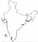
The given figure shows a portion of Southern India. The proposed site (Kudankulam) for the construction of two 1000 MW nuclear power plants has been labeled in the map as:
Match List I with List II and select the correct answer using the codes given below the lists:
| List (Resort) | List II (State) |
| A. Ckakrata | 1. Assam |
| B. Haflong | 2. West Bengal |
| C. Kalimpong | 3. Uttar Pradesh |
| D. Kufri | 4. Himachal Pradesh |
Codes
A B C D A B C D


