
Exercise 1
Embibe Experts Social Science Solutions for Exercise 1
Simple step-by-step solutions to Exercise 1 questions of Maps from Social Science Textbook of Competency Based Questions for Class VI. Also get 3D topic explainers, cheat sheets, and unlimited doubts solving on EMBIBE.
Questions from Exercise 1 with Hints & Solutions
Why is it not possible to show the accurate shapes of countries and continents on maps?
Use the map to answer the following questions.
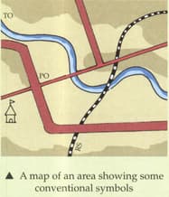
a) How many metalled roads pass through this area?
b) In which direction is the temple located with respect to the post office?
c) What type of railway line passes through the area?
Identify and name the countries marked on the map.

How is a physical map different from a political map?
Identify the following conventional signs.

Identify the following conventional signs.

Identify the following conventional signs.

What is a map? How is it helpful? Which values does it support?


