
Earliest Maps of India
Earliest Maps of India: Overview
This Topic covers sub-topics such as Maps of Medieval India, New and Old Terminologies in History and, Changes in Meaning of Hindustan
Important Questions on Earliest Maps of India
Who was the First French cartographer who drew map of India?
A _____ is a person who studies about maps.
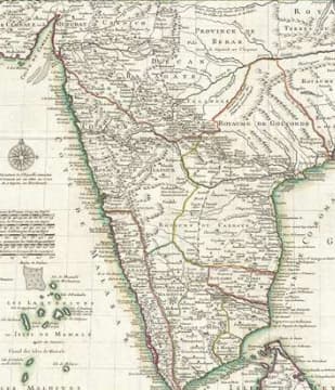
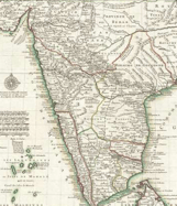
In the given map cartographer Guillaume de l'Isle shows twenty-first century India.
Al Idrisi, prepared a detailed Map of Europe in the twelfth century.
The map of Guillaume de l'Isle is more detailed than a map of Al- Idrisi.
This map given down is sketched by Al-Idrisi in the twelfth century.
The given map is sketched by a writer, not a cartographer.

A map was made in CE by the Indian geographer Al-Idrisi.
A cartographer is a person who studies Ancient artifacts.
The maps made by Al-Idrisi and the French cartographer were quite different.
Which of the following mapmakers traveled extensively and created maps based on his journeys through India and other parts of Asia?
Which ancient Indian scholar contributed to the early mapping of India, focusing on astronomy and geography?
Who is considered one of the earliest mapmakers whose work influenced the representation of India?
In what way did early maps of India often differ from modern maps?
What was one of the major influences on the changing representation of India in early maps?
How did the representation of India change over time?
Which of the following was a key factor in the geographical knowledge of ancient India?
What role did the Vedas play in the geographical understanding of ancient India?
How did early Indian civilizations understand geography?
How did explorers contribute to the creation of early maps of India?


